Driving · Road conditions
Driving to Lee Canyon and Brian Head in winter
Nevada chain rules, where to check road conditions (NDOT 511, nvroads), and winter driving tips for Lee Canyon and Brian Head, with sources.
Updated Nov 1, 2026 · 9 sources

Check nvroads.com or call 511 before you leave, and plan to lose your phone signal. NDOT says “cell phone reception is not available in most areas on State Route 156, State Route 157 and State Route 158,” the roads up Mount Charleston, and Lee Canyon says “there is no cell phone service at the resort.” Before you leave town, download an offline map of the route, save your tickets and confirmation emails to your phone, and tell someone your plan and when you expect to be back. Fill up with gas in town; Lee Canyon says services are limited on the mountain.
This page covers the rules and road-condition sources for the two winter drives most people from Las Vegas make. For the route, parking and timing to Lee Canyon, see how to get to Lee Canyon.
Nevada chain rules, in NDOT’s words
NDOT’s traction page says “Nevada chain requirements vary from chain requirements in other states.” When a requirement is posted, it’s one of two conditions:
| NDOT condition | What it means (NDOT) |
|---|---|
| Chains or Snow Tires Required | Vehicles under 10,000 GVW “are required to use snow tires or approved traction devices.” Four-wheel drive is OK with four mud-snow (M-S) tires. NAC 484.240(1). |
| Chains Required, Except For | “Chains required on all vehicles, except four-wheel-drive with four mud-snow (M-S) tires.” NAC 484.240(2). |
| Chains Mandatory | “Nevada does not use this condition.” |
You’ll see R-1, R-2 and R-3 on some sites, including Lee Canyon’s own tips page. Those are California’s levels; NDOT’s comparison shows Nevada’s rules differ. Follow the signs and NDOT’s wording.
What counts as a snow tire: NDOT says snow tires carry an M-S, M/S or similar sidewall marking and have at least 3/16 inch of tread; it says tires “should have both a mountain peak/snowflake designation and an M+S, M-S or M/S designation.” Approved traction devices include chains and, NDOT says, recently approved alternative devices made of fabric or plastic that wrap the tire tread.
Mount Charleston: what NDOT says
NDOT’s Mt. Charleston page covers the roads to Lee Canyon (SR-156) and Kyle Canyon (SR-157):
- Don’t chain up in a travel lane. NDOT says motorists who stop in travel lanes to put on chains will be cited. Pull fully off the road where it’s allowed.
- No-parking zones. Winter no-parking zones apply along SR-156, with fines from $190. Park only in marked lots.
- Carry extra food, water, clothing, a shovel and blankets, per NDOT.
- Snow play. NDOT points sledders to the Foxtail picnic area when there’s more than 12 inches of snow; see snow tubing and sledding near Las Vegas.
Lee Canyon is about 50 miles from Downtown Las Vegas by the resort’s count, and the map below measures 48.1 miles from US-95 at I-15 to the base area. Most of it is US-95; the last 17 miles or so climb SR-156.
NDOT’s winter driving tips
From NDOT’s safe winter driving page:
- Always carry chains in snowy areas, even with four-wheel drive.
- Keep your gas tank high.
- Turn off cruise control on snowy or icy roads.
- Four-wheel drive doesn’t mean you can stop or turn better on ice.
- Let someone know your route and when you expect to arrive.
NDOT’s list of what to carry includes tire chains and a tow strap, a flashlight and spare batteries, an ice scraper, a snow shovel, jumper cables, a small bag of sand, extra winter clothes, a blanket, non-perishable food and water, and first aid supplies. Your first ski or snowboard day has our storage-bin tip for keeping it all in the car.
Brian Head: check UDOT
Brian Head is in Utah, so Utah’s rules and road reports apply. Brian Head’s getting here page gives the route (I-15 north to Exit 75 at Parowan, then 14 miles up SR-143) and points drivers to UDOT Traffic or 511 for conditions. It also says the Cedar Breaks Scenic Byway (SR-148) and Rim Road are closed in winter, so don’t follow a map app that way. UDOT’s chain-up page explains Utah’s tire and traction rules. Trip planning is on Brian Head from Las Vegas.
The drive map
The map below shows the Lee Canyon route only. It’s drawn from OpenStreetMap and shows no live road conditions or closures; open nvroads.com for those. The map needs a connection to load, so don’t count on it once you lose signal: use your offline map.
Drive map: Las Vegas to Lee Canyon
Skip the map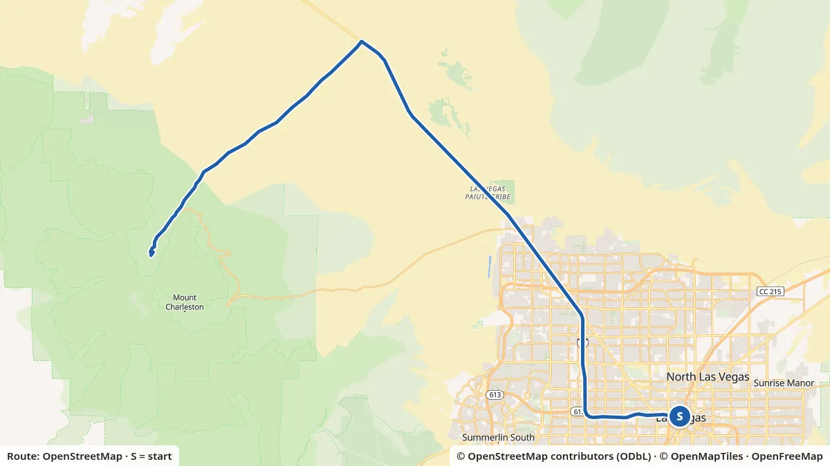
- Mapped distance
- 48.1 mi, start to finishMeasured along the OpenStreetMap line; published figure: about 50 miles from Downtown (Lee Canyon FAQ)
- Start
- Downtown Las Vegas (US-95 at I-15)Map start: US-95 at the I-15 interchange in Downtown Las Vegas
- Elevation
- 2,040–8,665 ftLow and high points, USGS 3DEP
- Surface
- 99% paved, 1% not taggedFrom OpenStreetMap surface tags
Slide or use arrow keys to read the elevation at any point.
Turn by turn
- 0.0 miStart at US-95 at the I-15 interchange in Downtown Las Vegas. Head west on Purple Heart Highway (I 11;US 93;US 95).
- 17.2 miContinue onto Veterans Memorial Highway (US 95).
- 20.7 miPass the junction with Alamo Road.
- 26.2 miCross Corn Creek Road.
- 30.7 miTurn left onto Lee Canyon Road (SR-156).
- 44.1 miPass the junction with Mack's Canyon Road.
- 44.8 miPass the junction with Deer Creek Road (SR-158).
- 48.1 miYou reach the Lee Canyon base area at the end of Lee Canyon Road (SR-156).
Directions are generated from the OpenStreetMap ways on the map. Check signs and closures with NDOT road conditions (nvroads.com) before you drive. The map shows no live road conditions; check nvroads.com or call 511.
Download GPX for Las Vegas to Lee CanyonLive Nevada road conditions (nvroads.com)Utah road conditions (UDOT Traffic)